Aerial
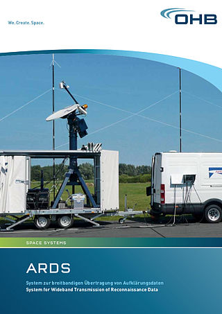
OHB DIGITAL’s CONDOR is a modular system for real-time aerial earth observation, monitoring, reconnaissance and data transmission. A flexible power glider flight platform serves as the operational carrier for state-of-the-art sensors and broadband radio data transmission. It also features real-time sensor data processing capabilities including networked image and information distribution. State-of-the-art sensor systems, such as high-definition video, high-resolution imaging, synthetic aperture radar (SAR) and hyperspectral cameras, ensure flexible deployment based on the specific requirements. The powerful data management offered by the ARDS transmission system processes all sensor data, transmitting it to a mobile ground station, which can be located up to 150 kilometers away.
The wide range of possible applications for the CONDOR system includes remote sensing for ecological missions, the provision of value-added services for agriculture, e.g. the assessment of irrigation and fertilization measures, the detection of environmental damage, infrastructure monitoring and the rapid provision of positioning information for search and rescue teams on site.
OHB DIGITAL uses modern methods for calibrating and processing data, supplementing it with artificial intelligence processes for mining information. This permits a better interpretation of images as well as immediate situational awareness for users.
OHB DIGITAL specializes in integrating these systems in aviation systems as well as installing ground systems for communications and image processing. Data and image processing methods are used to integrate interoperable sensor systems and information systems.